U.S. Department of Housing and Urban Development
Office of Community Planning and Development
Consolidated Plan Contact
CITIZEN'S SUMMARY
The City of Erie is located at the junction of Interstates 79 and 90 in
the northwestern section of the state of Pennsylvania on Lake Erie. The city is
the third largest in the state as of the 1990 census, and provides Pennsylvania
its only access to the Great Lakes. Because of its location, the City has had a
tradition of manufacturing as its economic base.
Action Plan
The City's sources of funding for the activities included in the
Consolidated Plan is Community Development Block Grant funds (CDBG), HOME
Investment Partnerships Program (HOME), and Emergency Shelter Grant Program
(ESG). The City will use its CDBG, HOME and ESG funds to complete a number of
activities in the City of Erie. Some of the activities are site specific while
other are activities are available on a City-wide basis. Site specific
activities are being undertaken to address health and safety concerns of
predominantly low-income households seeking to provide the most efficient use of
scarce resources based on critical needs. City-wide activities are available
to ensure equitable distribution of funds and provide opportunities for
redevelopment City-wide.
Citizen Participation
During the winter and spring of 1995, the City of Erie's Department of
Economic and Community Development conducted two public meetings to solicit
input into the preparation of the CP. Additionally, the City accepted comments
in writing. The public hearing was advertised in the local newspaper and
conducted in the evening at City Council Chambers.
In addition to the two public meetings, the City invited other governmental
agencies and nonprofits to provide insight and input into the goals and actions
that should be considered as a result of the consolidated planning process.
Each agency and nonprofit organization in the City was contacted by mail to
identify specific needs and subsequent actions to address needs.
Consultation with the Housing Authority of the City of Erie was made to
obtain data on the public housing inventory, including Section 8 Rental
assistance, and to discuss the Housing Authority's plans for public housing
development activities. The City also solicited input from social service and
homeless agencies providing housing assistance and related services to low and
moderate income persons. Comprehensive surveys were mailed to each of these
agencies.
Copies of the CP were distributed to various public locations as well as
sent to the Housing Authority for their comments. A summary of the CP was
published on March 15, 1995 in the local newspaper to alert interested persons
as to the availability of the CP. The CP was placed at five locations for
public review.
COMMUNITY PROFILE
The City of Erie is the largest city in Erie County. Between 1980 and 1990
the City experienced a 8.7% percent population loss. The decline has been
contributed to the economy of the area which was hard hit by the decline of the
manufacturing industries in the late 1970's and early 1980's. Erie, however, is
experiencing a rebirth with the growing plastic industry and other diversified
industries. In addition to these industries, the city also relies on tourism
because its proximity to Presque Isle State Park and the beaches of Lake Erie.
HOUSING AND COMMUNITY
DEVELOPMENT NEEDS
Conditions
- The top two employers in the City are General Electric and Zurn Industries
as of 1992.
- In 1990 the median family income (MFI) for the Erie Metropolitan Area
(MSA) was $32,145 for a family of four. According to information released by
HUD in May, 1993, 45.38 percent of Erie's population was low- and
moderate-income (LMI) with annual incomes of $25,716 or less for a family of
four.
Housing Needs
Because of the old age of the City's housing stock in combination
with a high incidence of low- and moderate-income households, the City housing
continues to need rehabilitation. There also continues to be the need for home
buyer assistance among lower income renter households.
Market Conditions
Fifty-two and one half percent of the City's 45,424 housing units is
owner- occupied. Median value of the owner-occupied housing stock is $43,000.
Median contract rent is $231. The U.S. Census reports that there is a city-wide
vacancy rate of 7.2 percent.
Affordable Housing Needs
While the availability of units for owner-occupancy is small, the
majority of the units are affordable to households with income below 80 percent
of the median. Up to 60 percent of the units are affordable to households
between 30 and 50 percent of the City's median income and almost one-third are
affordable to households with income below 30 percent of median. Similarly, 99
percent of the vacant for-rent units in Erie are affordable to households with
incomes below 80 percent of the median and 83 percent are affordable to
households between 30 and 50 percent of the City's median income.
Homeless Needs
Service providers for the homeless indicate that the most pressing
need in the community for the homeless population is affordable rental units.
Services are also needed for the transitional time between leaving a shelter and
moving into an affordable rental unit. In addition, the provision of a continuum
level of support services is needed to assist individuals and families in
maintaining self- sufficiency once it is achieved.
Public and Assisted Housing Needs
Because of the old age of the public housing stock in the City of
Erie, there is the need for continuous rehabilitation and modernization.
Barriers to Affordable Housing
Generally, the regulatory and administrative policies in Erie do not
impede affordable housing in the City. A significant concern in Erie is housing
quality with much of the old housing stock in need of constant repair.
Affordability is most often limited by a household's ability to save toward a
downpayment and the transaction costs associated with the purchase of a home.
Fair Housing
In 1991 the City completed a Fair Housing Analysis. The City
has been implementing the recommendations of the Fair Housing Analysis
ensuring impediments to the provision of fair housing do not exist in the City
of Erie.
Lead-Based Paint
Lead paint is typically found in homes that were constructed prior to
1978. Since most of the units in the City of Erie are older, the probability of
finding lead paint is high. There is a significant portion of the City's
housing stock that is occupied by low income households, renters and owners,
which potentially contains lead-based paint and consequently, poses a health
hazard to children younger than age 7.
Community Development Needs
Due to the old age of much of the City's infrastructure along with
limited resources resulting from a continuously decreasing and poorer population
residing in Erie much of the City's infrastructure is in need of maintenance and
replacement. Another major community development needs in the City are public
facilities improvements, commercial and residential rehabilitation, public
services, removal of architectural barriers, historic preservation, economic
development, code enforcement, acquisition, and disposition.
Coordination
The City of Erie's Department Economic and Community Development,
taking direction from the City Council, is responsible for administration of the
City's CDBG, HOME and ESG funds. As such, the Director of the Department of
Economic and Community development coordinates many of the activities described
in the Consolidated Plan. The City works with public agencies providing housing
resources, assisted housing providers, and private and public social services to
coordinate housing and support service efforts.
HOUSING AND COMMUNITY
DEVELOPMENT STRATEGY
Vision for Change
Erie's goal is to create a strong, viable, and revitalized community.
Through the coordinated efforts of all persons and organizations, pride in the
community can be restored, and children can be given a feeling of hope for their
future. Working with and through human service organizations, the dependency on
human services can be lessened as families become more economically and socially
self- sufficient.
Housing and Community Development Objectives
The objectives are to use scarce resources in an efficient manner
benefitting the greatest number of persons and households with an emphasis on
assistance to low- and moderate-income households.
Housing Priorities
The City of Erie's housing priorities include maintaining and
increasing rental assistance; providing homebuyer assistance for first-time
homebuyers; providing rehabilitation of less than $25,000 for housing units to
households at 0% to 80% of median income; providing rehabilitation for lower
income rental households, including households with special needs; provide
support for homeless and transitional facilities and services in the City; and
preserving and expanding the supply of affordable housing through acquisition in
conjunction with rehabilitation and or new construction.
Non-Housing Community Development Priorities
The major non-housing community development priorities in the City
are public facilities and improvements; commercial rehabilitation; public
services; removal of architectural barriers and curb cuts to improve
accessibility; historic preservation; economic development; acquisition,
disposition, clearance, and code enforcement.
Anti-Poverty Strategy
In an attempt to reduce the number of families living in poverty in
Erie, the City will continue to provide CDBG, HOME, and ESG funds to social
service agencies which attempt to integrate the provision of social services and
affordable housing activities for households below the level of poverty. The
City of Erie is placing a special emphasis eliminating poverty among its
children. The City's reasoning is based on the statistics from the 1990 census
which showed the City of Erie had one of the highest levels of child poverty in
the country.
Housing and Community Development Resources
The City will use CDBG, HOME and ESG funds to carry out the programs
described in its Consolidated Plan. In Fiscal Year 1995 the City's CDBG
entitlement is $4,722,000, it HOME entitlement is $1,068,000 and its ESG
entitlement is $167,000. Additionally the City has available $50,000 of program
income.
ONE-YEAR ACTION PLAN
Description of Key Projects
- General Administration
- Disposition - City-wide
- Renovations to various neighborhood centers
- Street Improvements throughout the City
- Park/Playground Improvements
- Owner-Occupant Housing Rehabilitation - City-wide
- Historic Preservation- Warner Theater
- Remove Architectural Barriers - Handicapped Ramps
- Code Enforcement - City-wide
- Clearance
- Funding of various public service agencies - City-wide
- Relocation
- Commercial Rehabilitation - West 18th Street and Parade Street
- Special Economic Development - Entrepreneurial Outreach, Revolving Loan
- Interim Assistance - Trash Removal
- Planning and Capacity Building
- Acquisition of Real Property - St. Paul Acquisition
- Community Policing
Lead Agencies
The City of Erie's Department of Economic and Community Development.
Housing Goals
The City projects funding rehabilitation of 120 units in the City
during Fiscal Year 1995.
Maps
MAP 1 depicts points of interest in the jurisdiction.
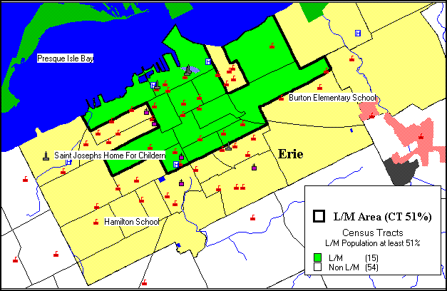
MAP 2 depicts points of interest and low-moderate income areas.
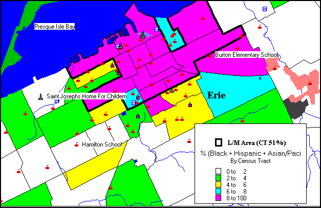
MAP 3 depicts points of interest, low-moderate income areas, and minority concentration levels.
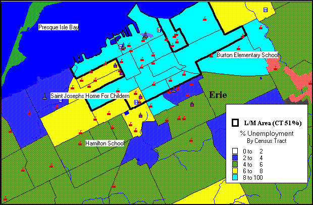
MAP 4 depicts points of interest, low-moderate income areas, and unemployment levels.
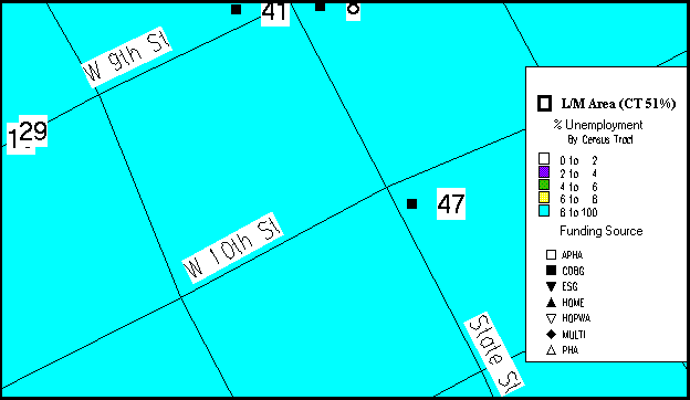
MAP 5 depicts points of interest, low-moderate income areas, unemployment levels, and proposed HUD funded projects; in addition: a table provides information about the project(s).
MAP 6 depicts neighborhood streets and proposed HUD funded projects, as described in the table under MAP 5.
To comment on Erie's Consolidated Plan, please contact:
Jeffrey Spaulding
Director
Department of Economic and Community Development
PH: (814) 870-1275
Return to Pennsylvania's Consolidated Plans.